Point Cloud to CAD conversion
Turn raw scan data into dependable 2D drawings—swiftly, accurately, and ready for design
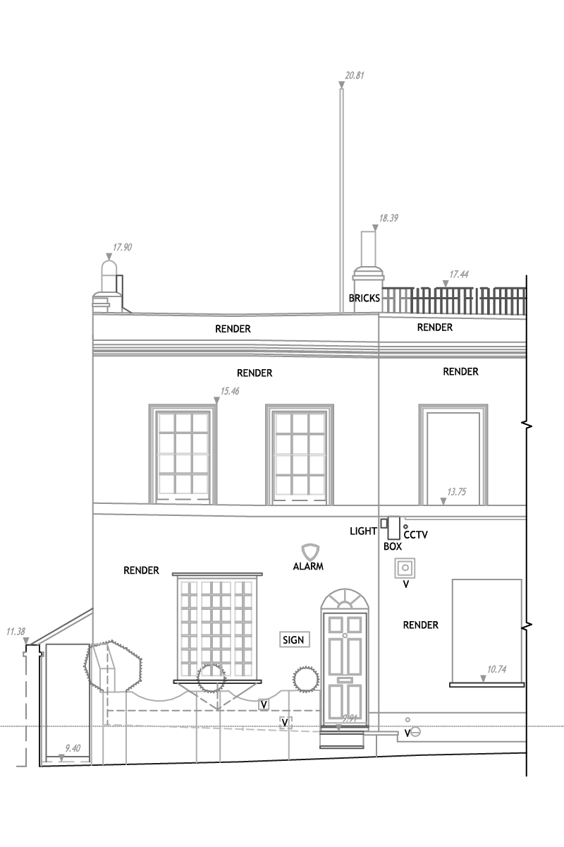
When you’re redesigning an existing building, every millimetre counts. Our Point Cloud to CAD service transforms high‑resolution laser‑scan data into precise 2D floor plans, elevations and sections so your team can start drawing immediately—no guess‑work, no return site visits, and 0 % human error.
Our Point Cloud to CAD deliverables. Speak to an expert now for a fast quote: 07730 591 665
Floor plans: full layouts of every level, including basements, mezzanines and loft voids
Elevations: millimetre‑accurate internal and external façades, ready for annotation
Sections & call‑outs: targeted vertical cuts showing structure, floor‑to‑ceiling heights and services
Reflected ceiling & roof plans: overhead drawings capturing beams, joists, pitches and drainage falls
Façade details & window schedules: granular fenestration and cladding data for tender or manufacture
Topographic / site plans: boundaries, spot heights, landscaping and access routes in context
Clean layered outputs: organised DWG, RVT and PDF files that drop straight into your CAD/BIM workflow
Level of Detail 100–300: choose the resolution you need, from outline concept to full construction docs
Any building. Any size.
Any mainland UK location.
Surveying London & beyond
-

0% Human Error
Advanced 3D laser scanning for precision data
-

Fast response times
Rapid availability across London & UK
-

2D & 3D as-built drawings
Delivered in CAD, Revit & BIM formats
-

Experienced Surveyors
Trusted by industry professionals
Why Architects & Developers choose Scan‑to‑CAD
Featured projects
FAQs
-
Point Cloud to CAD converts raw 3‑D laser‑scan data into precise 2‑D drawings—plans, sections and elevations—ready for design, planning or tender.
-
Depending on the scale of the survey, we start from +/- 5mm.
-
Standard projects land in your inbox within 5–7 working days of receiving the point cloud. Expedited 48‑hour delivery is available for smaller or urgent jobs—just ask.: 07730 591 665
-
Layered DWG, RVT and PDF come as standard, together with E57 or RCP point‑cloud files. Other formats are available on request.
-
We accept and deliver E57, RCP/RCS, PTS and LAS files. If your scan was captured on FARO, Leica or Trimble equipment, we can work with the native data too.
-
Yes. If you don’t yet have a point cloud, our in‑house laser‑scanning team can survey the site and feed the data straight into our CAD workflow.
-
We import the laser‑scanned point cloud into specialist software, register and clean the data, then draft over it in AutoCAD or Revit to produce accurate 2‑D floor plans, elevations and sections—ready for your design team.
-
AutoCAD, Revit, Cyclone Register 360 and Recap are our daily tools. That means your as‑built drawings open natively in the platforms most architects and BIM teams already use.
-
Absolutely. Our surveyors specialise in heritage and non‑orthogonal structures, capturing high‑density scans that translate into reliable CAD drawings—even where walls aren’t square.
-
We do. If you need a full 3‑D Revit model instead of 2‑D CAD, our Scan‑to‑BIM service delivers data‑rich as‑built models suitable for coordination and clash detection.